

In early 2018, two students in the final year of their Master’s in Landscape Architecture program at PennDesign were standing on shores of the Mediterranean Sea on either side of the border, calling out each other’s names. One was in Lebanon. The other was in Israel.
Editor's Note: An earlier version of this story erroneously referred to “Israel/Palestine.” The headline and subsequent uses have been corrected.
Civilians are legally barred from crossing the border. So the students “traversed” it, traveling the length of the border on either side, cataloging the terrain, collecting oral histories, and carrying out simultaneous actions, like calling to each other from across an expanse of water.
Sarah and Rivka, who asked that their last names be withheld because of the political repercussions of their work, traversed the border for the first time last summer, on a travel grant from the Van Alen Traveling Fellowship and the Graduate and Professional Student Assembly, for a proposal called “(dis)joint mapping: A proposal to investigate and map the landscape of the Demarcation Line between Lebanon and Israel/Palestine [sic].” In the fall, they decided to turn the work into an independent research design studio, advised by Lucinda Sanders, an adjunct professor of landscape architecture at PennDesign and CEO of OLIN. The result of their independent study, a multi-format, interdisciplinary thesis called “Here/There: Middle East Borderlands,” draws on landscape architecture, performance studies, and printmaking.
“The question of war landscapes is something that has been in my mind for about 18 years,” says Sarah, who was displaced from her home more than once during her childhood because of conflict, Israeli occupation, and war.
“I think for me, the question of borders is only becoming more and more pressing, globally. I am interested in looking at this security apparatus, and seeing what it does to socio-political and ecological systems in the region,” says Rivka.
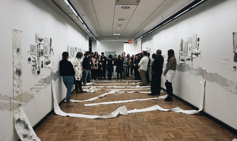
Sarah and Rivka capped off the research with a performance and exhibition in Meyerson Hall in April. The presentation consisted of drawings, prints, archival maps and materials, videos, and readings from interviews and journal entries. Some of the readings were presented simultaneously, sometimes reading the same text in unison, sometimes divergent texts overlapping. The “investigation” was driven by a core question: What does a border do to a landscape?
“The landscape is continuous, but so many of the cultural and political aspects are discontinuous,” says Sanders, who advised the independent studio. “What they were able to capture were the cultural continuities that preceded this division.”
Sanders says that the research methods of landscape architecture aren’t as systematized as they are in other disciplines. The traditions aren’t as deep. And she’s interested in how critical research in the field might be expanded.
“This mixing of design studio and research and what the output is, I think, is something that is still really being explored,” Sanders says. “Does it need to be a physical intervention to be classified as a design studio, as an independent study? My feeling is no, it doesn’t. It can open up a whole series of questions that are super important. And I think Sarah and Rivka did that.”
Sarah and Rivka say they were interested in questioning the role of designers in naturalized war landscapes. Naturalized war is a term they employed in their project, and which was coined by Lebanese anthropologist, Munira Khayyat, to describe a situation where war is so pervasive that is becomes ‘naturalized’ into the landscape and everyday life. Traditionally, they say, architects have intervened in such places only after periods of conflict have ended, through reconstruction and memorials. They meant to explore how designers might intervene within times of conflict.
Their second trip to the borderlands was built around “analogous sites” on either side of the border that are connected by continuous natural systems. Ultimately, they decided to employ more “analog methods of representation” than digital media for the final work. They felt that the questions they were asking about the landscape had to be approached from a variety of angles and through performative and collaborative means. The installation was framed by painted plaster-on-fabric ground pieces exploring the morphology of the terrain (parent material: chalk) as it unfolds across their transect (chalk limestone, alluvial fans, igneous basalt). On either side of the room, they installed mirrored acrylic sections revealing a scaled depiction of the topography of the entire borderlands terrain.
“It was the most collaborative work we’ve ever done” say Sarah and Rivka. “We co-created the installation and performance as a projective ‘third space’ in Philadelphia, in between the border, where the borderlands can be explored in the form of radical artwork and design. A third space which can hold conflicting, opposing, sometimes overlapping narratives; a third space which can contain both sides and places simultaneously.”